


.png)
 - Vertical.png)
.png)
 - Vertical.png)
.svg)
.png)
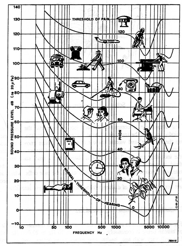
GNSS Bands
GPS (US)
Glonass (Russia)
Galileo (UK)
BeiDou (China)
NavIC (formerly IRNSS) (India)
QZSS (Japanese SBAS)
GPS/GAGAN (Indian SBAS)
All Bands and Frequencies of all Constellations
L1 - Military, L2C - Consumer, L5 - GPS, QZSS, E5 - Galileo, G3/B3 - Glonass/Beidou
GNSS Augmentation Systems
Types
Satellite Based (SBAS), Ground Based (GBAS), Aircraft based (ABAS)
Wide Area Augmentation System (WAAS), Local Area Augmentation System (LAAS)
- DGNSS (NTRIP)
- RTK (NTRIP Protocol, RTCM3.x or other open data formats) / OSR (Observation State Representation) - CPDGNSS
- PPP (Proprietary Data Formats) (not DGNSS, uses internet correction providers like IGS (International GNSS), unidirectional communication, slow <3-30 min, <10 cm, long range (global))
- PPP-RTK / SSR (State Space Representation) (SPARTN Data Format)- same accuracy, PPP coverage (continental), lower bandwidth than RTK, as fast as RTK, unidirectional communication); uBlox PointPerfect has SSR (cm level in <30 sec)
-
Trimble RTX (similar accuracy to GAGAN (from a Paper, for Sri Lanka))
-
Network RTK (NRTK)
- Wide Area RTK (WARTK) - developed by gAGE/UPC (Research Group of Astronomy and Geomatics/Technical University of Catalonia) (Unlike RTK, doesn't assume Ionosphere delay is same for all users, instead broadcasts the data with different algorithms ref: Navipedia, the Offcial European GNSS WIki)
Wide Area DGNSS (WADGNSS)
- GPS and Geo Augmented Navigation (GAGAN) (Indian SBAS)
- WAAS (Wide Area Augmentation System) - USA
- EGNOS - the European operational SBAS
- MSAS - the Japanese operational SBAS
- CDGPS - Canadian Differential GPS